The Trough of Bowland is a remote and scenic valley located in the Forest of Bowland, an Area of Outstanding Natural Beauty (AONB) in Lancashire, England. Known for its peaceful landscapes, rolling hills, and rural charm, the Trough of Bowland has become a favorite destination for walkers, cyclists, and nature enthusiasts. Its natural beauty is matched by a rich cultural and ecological history, making it an important part of the northwestern English countryside. Exploring the Trough of Bowland reveals more than just a quiet landscape it offers insight into geology, wildlife, local traditions, and land use.
Geographical Setting and Landscape
Location and Boundaries
The Trough of Bowland lies in the northwestern part of England, forming part of the Forest of Bowland AONB. It stretches roughly between the villages of Dunsop Bridge in the east and Quernmore in the west. The valley itself acts as a natural route through the Bowland Fells, which are known for their upland character and wild terrain. Though not a particularly deep trough in geological terms, the valley stands out as a striking contrast to the surrounding hills and moorlands.
Landscape Features
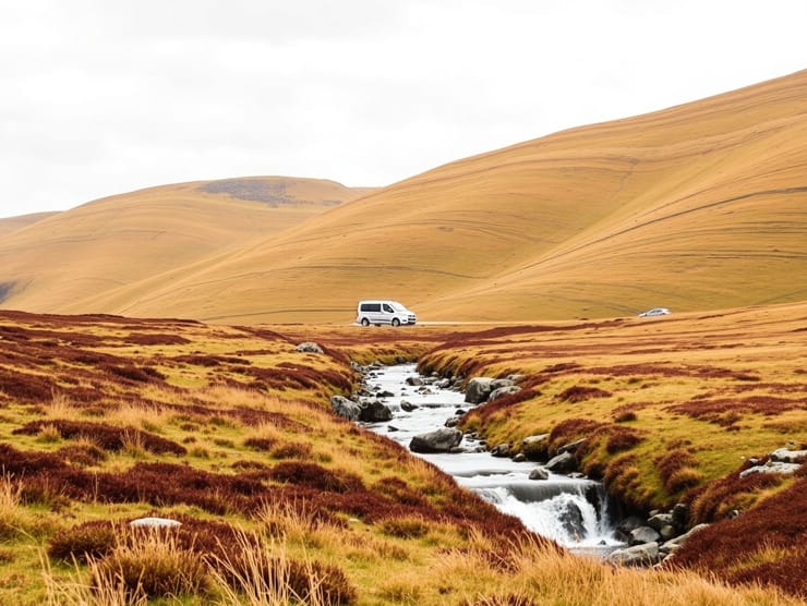
- Rolling moorland and heathland
- Steep-sided valleys and wooded slopes
- Stone-walled fields and traditional farmhouses
- Streams and small rivers, such as Langden Brook
The landscape changes subtly with the seasons, with vibrant greens in spring and summer, earthy tones in autumn, and misty, atmospheric views in winter. The varied scenery makes the Trough of Bowland a popular spot for photography and outdoor recreation.
Geological Background
Formation of the Trough
The Trough of Bowland is part of a larger region shaped by millions of years of geological processes. The area consists mainly of gritstone, sandstone, and shale formed during the Carboniferous period. Over time, glacial activity during the last Ice Age helped sculpt the present-day valleys and uplands. Erosion and the movement of ice sheets played a role in deepening the natural channels and forming the characteristic rugged hills seen today.
Soil and Vegetation
The soils in the Trough are typically acidic and peaty, supporting moorland vegetation such as heather, bilberry, and cotton grass. In lower-lying areas, improved pastureland is used for grazing sheep and cattle. Wooded areas with oak, ash, and birch are found along valley sides and stream courses, adding diversity to the plant life.
Wildlife and Biodiversity
Bird Species
The Trough of Bowland is recognized for its birdlife, especially upland species that depend on moorland and heath. Notable birds found in the region include
- Hen harriers
- Merlins
- Curlews
- Golden plovers
- Skylarks
Hen harriers, in particular, have become symbolic of conservation efforts in the area. These birds of prey are rare and have faced habitat loss and persecution in the past. The Forest of Bowland has been part of initiatives to protect their nesting and feeding grounds.
Mammals and Flora
Mammals such as red deer, stoats, and foxes inhabit the region, although they are more elusive than the abundant sheep and cattle raised by farmers. Wildflowers such as bluebells, primroses, and buttercups bloom in wooded and grassy areas, contributing to the area’s rich biodiversity.
Human Influence and History
Farming and Land Use
The Trough of Bowland has long been used for agriculture, particularly sheep farming. The traditional field systems, stone barns, and dry stone walls that dot the landscape reflect centuries of rural life. Much of the land is managed as common grazing land, while parts are privately owned or managed by water authorities.
Historical Significance
Historically, the Trough served as an important route across the hills, connecting Lancashire and Yorkshire. Its quiet lanes were once used by packhorses and drovers. During World War II, the area was also used for military training exercises, taking advantage of its remote and rugged terrain. Though no major battles or settlements occurred here, the cultural memory of past use remains part of its identity.
Tourism and Outdoor Activities
Walking and Hiking
One of the main reasons people visit the Trough of Bowland is for walking. Trails vary from gentle riverside walks to more challenging hikes up surrounding hills such as Ward’s Stone or Clougha Pike. Paths are well-marked and often lead through peaceful countryside, offering panoramic views and wildlife sightings.
Cycling and Driving Routes
The Trough is also popular with cyclists, especially road cyclists looking for scenic and hilly routes. The quiet roads and low traffic levels make it ideal for long rides. Drivers often take the narrow route through the valley for a leisurely journey filled with scenic pull-offs and picnic spots.
Visitor Facilities
While the area remains largely undeveloped, there are a few tearooms, farm shops, and pubs in nearby villages such as Dunsop Bridge and Slaidburn. These provide a welcome stop for travelers and contribute to the rural charm of the experience.
Environmental Conservation
Protected Status
The Forest of Bowland, including the Trough, is designated as an Area of Outstanding Natural Beauty. This status helps protect the landscape from overdevelopment and supports conservation efforts for wildlife and natural habitats. Local councils and conservation groups work together to maintain the balance between tourism, agriculture, and nature preservation.
Threats and Challenges
Despite its protected status, the Trough of Bowland faces environmental pressures. These include
- Overgrazing in upland areas
- Climate change affecting moorland ecosystems
- Visitor impact on footpaths and sensitive habitats
Efforts such as responsible tourism campaigns, habitat restoration, and volunteer projects aim to mitigate these issues and ensure the Trough remains a valuable ecological and cultural asset.
Community and Local Life
Rural Communities
Life in and around the Trough of Bowland is shaped by its isolation and agricultural economy. Small villages and hamlets maintain strong community ties, with events, fairs, and markets forming part of the social fabric. Farming remains a central occupation, although tourism has added new opportunities for income.
Education and Awareness
Programs to educate visitors and residents about the area’s history, ecology, and responsible land use are ongoing. Interpretation boards, guided walks, and school outreach programs help promote understanding of the Trough’s importance and encourage stewardship of the landscape.
The Trough of Bowland is more than just a beautiful valley; it is a living landscape rich in history, wildlife, and rural culture. As part of the Forest of Bowland, it holds environmental, recreational, and cultural value that continues to inspire locals and visitors alike. Its rugged hills, quiet roads, and traditional farms offer a glimpse into a slower, simpler way of life, while its protected status helps ensure that future generations can enjoy its beauty. The Trough remains one of England’s best-kept natural treasures, inviting those who seek peace, nature, and authenticity.